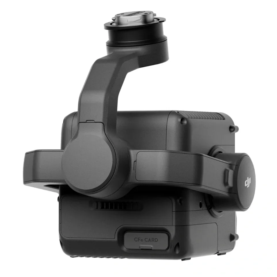
DJI Zenmuse L3 Lidar Sensor
DJI Zenmuse L3 Lidar Sensor


Free Shipping
Regular price
$17,400.00
Regular price
$0.00
Sale price
$17,400.00
Unit price
per
Shipping calculated at checkout.
Couldn't load pickup availability
Availability:
Sorry we are out of stock but have more on the way.

You will earn 8700 Electron Reward Points on this product!
Click to find out more about our points program and save big!
Low Price Promise!
Click to find out more about our low price promise
DJI Zenmuse L3 Long Range Lidar Sensor
Key Features:
- 1535nm Long-Range LiDAR
- Dual 100MP RGB Mapping Camera System
- High-efficiency mapping: covers up to 10km² per flight or 100km² per day
- Survey-grade accuracy: delivers 2–4 cm precision for mapping applications.
- Adjustable point-rate control: 100 kHz – 2 MHz to balance density and coverage.
- Compact low-power design: 1.6 kg payload draws only 64 W typical power.
- Dual 100 MP Micro 4/3 cameras: generate orthophotos and colorized point clouds.
In The Box:
- DJI Zenmuse L3 LiDAR Gimbal Camera
- Single Gimbal Connector
- 2x 1TB CFexpress Type-B Memory Card
- CFexpress Type-B Card Reader
- Storage Case
- Lens Cleaning Cloth
- Matrice 400 Carrying Case Insert
- Screws and Tools
- 4x Gimbal Damper
- Lens Cap
Overview:
DJI's next-generation high-accuracy aerial LiDAR system features a long-range LiDAR capable of reaching up to 950m even on objects with just 10% reflectivity. Dual 100MP RGB mapping cameras and a high-precision POS system accelerate geospatial data acquisition, enabling daily coverage of up to 100 km². Equipped with a 1535nm Class 1 laser and dual 100 MP Micro 4/3 cameras, it delivers up to 950m range and 2–4cm accuracy for professional surveying and digital-twin applications. Built exclusively for the Matrice 400 RTK, the L3 integrates seamlessly into DJI Terra workflows to output point clouds, orthophotos, and 3D models—all within a single processing environment.
Zenmuse L3 achieves a maximum detection range of 950m at a pulse rate of 100kHz, tested under 100klx ambient light and on objects with 10% reflectivity. The adjustable pulse rate allows for flexible power output and optimal adaptation to different operational scenarios. Typical flight altitudes of 300 to 500m significantly expand single-flight coverage and boost mapping efficiency.
With a laser beam divergence of just 0.25 mrad (1/e²), the spot size at the same range is about one-fifth that of Zenmuse L2, enabling detection of smaller objects such as power lines and branches. Higher energy density results in stronger penetration capability, significantly increasing ground point density beneath vegetation and enabling high-accuracy reconstruction of complex terrains and structures.
With maximum laser pulse emission frequency of 2 million pulses per second and support for up to 16 returns, Zenmuse L3 delivers highly accurate spatial reconstruction. Point cloud density and penetration capability can be adjusted to fit needs from high-accuracy mapping to complex environments.
Supports Linear, Star-Shaped, and Non-Repetitive scanning modes for different operational scenarios:
• Linear: Achieves more consistent point cloud distribution, ideal for high-accuracy terrain mapping.
• Star-Shaped: Balances accuracy with multiple scan angles and penetration capability, well-suited for forests or dense urban environments.
• Non-Repetitive: Provides multiple scan angles and broader coverage, optimized for power line inspections and other complex structural surveys.
Dual 100 MP Micro 4/3 sensors with 107° FOV capture ultra-sharp color imagery for photogrammetry and point-cloud colorization. The system delivers 1.2cm GSD at 120m AGL or 3cm GSD at 300m, ensuring photorealistic results for engineering-grade mapping.
The IP54-rated housing withstands rain, dust, and temperature extremes from -25°C to +55°C. Powered by DJI’s unified ecosystem, the L3’s workflow with DJI Terra and Modify offers real-time point-cloud preview, on-site measurement, and automated accuracy checks—all backed by 1-Year DJI Care Enterprise Plus coverage.
The upgraded high-precision POS system achieves heading accuracy of 0.02° and pitch accuracy of 0.01° (post-processed, 1s). The self-developed LiDAR delivers ranging repeatability of 5mm at 150m (1s) and supports microsecond-level time synchronization. Each unit undergoes rigorous factory calibration to ensure consistently reliable survey results.
Vertical accuracy is better than 3cm at 120m altitude, better than 5cm at 300m, and better than 10cm at 500m, easily supporting mapping projects at 1:500, 1:1000, and 1:2000 scales. The point cloud thickness produced by Zenmuse L3 is only half that of Zenmuse L2, supporting advanced analysis and high-accuracy applications.
With a smaller laser spot and higher single-pulse energy, Zenmuse L3 offers superior penetration capability. In terrain mapping and similar applications, it captures more ground points with greater completeness, significantly improving the accuracy and integrity of terrain data for precise surface fitting and reconstruction.
When mounted on DJI Matrice 400, Zenmuse L3 delivers outstanding efficiency. At a flight altitude of 300m, a single flight can cover up to 10km², enabling up to 100km² of daily coverage.

- Choosing a selection results in a full page refresh.
- Opens in a new window.